Words: Mike Vernon
Since 1845, the Boat Race has, with just a few exceptions such as wartime and COVID, been held on what became known as The Championship Course – from Putney to Mortlake. The River Thames remains the same, but modern-day rowers would not recognise much about the riverbanks of the course way back in history.
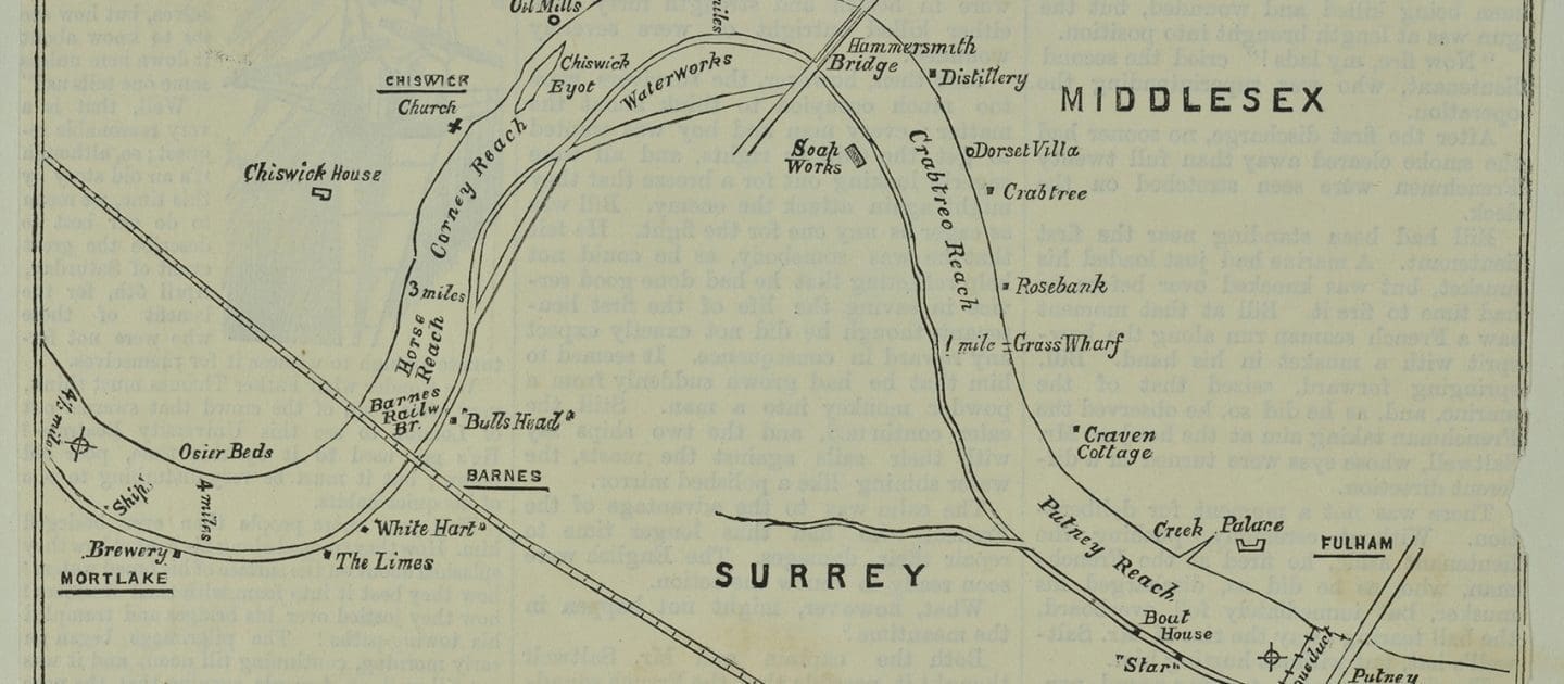
This 1879 map, held by The London Picture Archive, is believed to be the oldest map of The Championship Course as a distinct entity. Come with us as we journey from Putney to Mortlake.
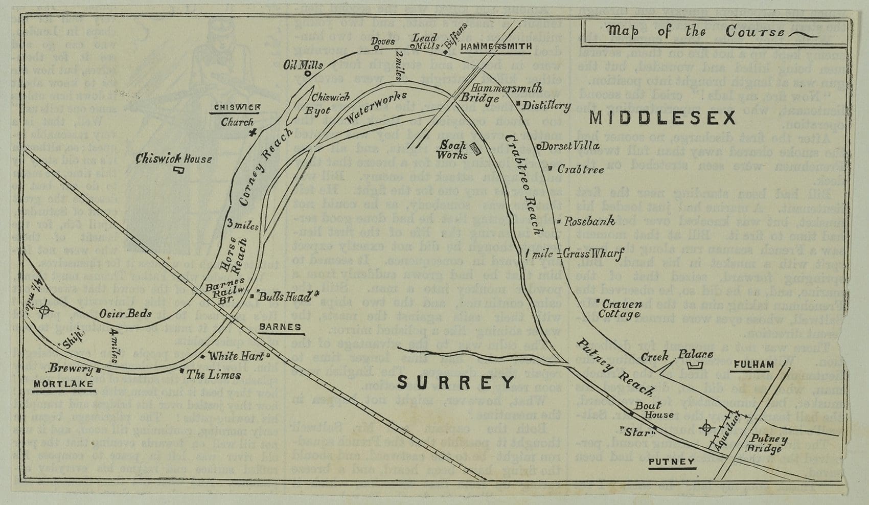
Wandsworth Riverside: Map of the Oxford/Cambridge Boat Race course from Putney Bridge to Mortlake, image source: Metropolitan Prints Collection, The London Archives (City of London Corporation).
London’s Boat Race
In 1829, the first Boat Race was rowed from Hambledon Lock to Henley. By 1845 it had moved downriver to West London, and by the mid-century it had become something of a Cockney Festival: on the chosen April morning, it seemed that every Londoner was involved with the Light Blues or Dark Blues. Ribbons of either light or dark blue were fastened around the necks of costermongers’ donkeys, tied around dust carts, fastened to the whips of cab men or worn as scarves by match boys.
The river was packed with barges and launches; the towpaths and Hammersmith Bridge with spectators. The more courageous perched on high on parapets and arches to the point of danger.
From Putney
Starting at Putney, the first identifiable feature on the 1879 map is that the crews rowed under an iron trough aqueduct which supplied drinking water to Chelsea Waterworks on the north side of the river. The Thames was becoming more polluted; in the 1850s it became illegal to drink water from the river. A new Putney Bridge was built in 1884 and incorporates the old aqueduct underneath the pavement; it is still used to convey drinking water.
From Putney they rowed past the Star Pub (now the Star and Garter, and currently closed) on the south bank which was originally built as a hotel for the boating and sailing community with a boathouse on the ground floor.
Craven Cottage is next on the north bank. Originally a mansion built by Baron Craven in 1780, an English peer from Berkshire, at the time it was surrounded by forestry. It burned down in 1888 and became the football stadium of Fulham FC, and is now seen from the river as Fulham Pier, rising out of the north bank of the course.
Industry at Hammersmith
As the race heads under Hammersmith Bridge, we can see a number of industrial sites marked. Industry tended to be located upriver with their unpleasant smells, distanced from residential areas: the Haig Distillery on the north bank near Hammersmith Bridge; built in 1857 and famous for scotch whisky, which closed in the 1980s; Mambre Saccharine Co with a factory next to the Haig Distillery, producing starch, sucrose, treacle, glucose and syrup which was demolished in 1979; and on the opposite bank, Colonel Cowan built a soapworks in 1857, which became Harrods Depository after 1892. There are many ways of making soap but typically an alkali (such as sodium hydroxide) is boiled with an oil or fat (such as olive oil or tallow). This could have been an odorous process.
Beyond Hammersmith Bridge we can see a reference to Biffens the boatbuilders on the north bank. Biffens started in the 17th Century, building small Thames fishing boats, when the river had plenty of fish; it later expanded into all sorts of sculling and pleasure boats for sale, hire or export. Members of five generations of the Biffen family successfully raced their boats on the Thames.
Also based around Hammersmith were Lead Mills (possibly giving Hammersmith its name). These turned lead ingots into sheets for roofs, ammunition, and later batteries.
Next up on the same bank is marked as ‘Doves’ – now The Dove, a Fuller’s pub with a perfect vantage point for spectators on Boat Race Day. The Dove is where James Thomson wrote the lyrics for Rule Britannia.
Further upriver was the East India Albert Oil Mills, notorious for the pollution it pumped out through its large chimneys.
Coat of Arms on Barnes Bridge
Barnes Railway Bridge was originally built in 1849 and replaced in 1890. In recognition of its link with The Boat Race, the Coat of Arms on Barnes Bridge includes both a Light Blue oar and a Dark Blue oar.
Mortlake Brewery was founded over 500 years ago, in 1487; by the time of this map, it was primarily supplying beer to the British Army in India (which is where India Pale Ale or IPA has come from). Large quantities of weak beer were drunk, as it was safer than drinking water.
As the finishing line hove into view, rowers passed osier beds on the north bank. Osiers are a type of willow, providing the osier rods harvested for fish (especially eel) traps, fencing, baskets and containers, and even defences for the river bank. The osiers were cut in March and placed in trenches of water; when the sap rises in May the osier cutters peel the bark and draw forth the pliable rods.
The scenery and landmarks will evolve with every generation – what doesn’t change is the fight on the river to be crowned the winner.